Home
Interactive Google Map
>> Open Google Maps
FROM POINTS NORTH:
Follow Route 3 South into Massachusetts. Take exit
32 off of Route 3 at North Chelmsford. You will
immediately be on a rotary. Well it was a
rotary a few years ago. Now it's some hack of a
traffic design that only a Bostonian could love.
Basically, you want to straight off the exit, get to
your left so that you can make a left to cross back
over Rt 3 and head straight onto Drum Hill Road.
Two or three orbits of this interchange should be all
you need to master these directions. You're on
Drum Hill Road when you see paradise - a Starbucks on
the left and a Dunkin Donuts on the right among other
strip mall tenants. Follow this road straight
through TWO sets of lights. At your THIRD set of
lights bear left through the fork. Follow straight through
TWO MORE
sets of lights (Market Basket on left and White Hen
Pantry on your right). This will put you on the Rourke
bridge which passes over the Merrimack river. Take a
right off of the bridge. The boathouse is 200
meters down on the right.
FROM POINTS SOUTH or WEST:
Follow either I-495 North or 128 North (i.e., I-95
N). Take to Route 3 North. Take exit 32 off of Route 3
at Rt.4 in Chelmsford. Take your first right at
the stop at the top of the exit. Follow
that straight through two sets of lights. At your
third set of lights bear left through the fork.
Follow this road straight through two more sets of lights
(Market Basket on left and White Hen Pantry on your
right). This will put you on the Rourke bridge which
passes over the Merrimack river. Take a right off of
the bridge. The boathouse is 200 meters down on
the right.
FROM POINTS EAST:
If you coming from northeast MA, Portsmouth NH, or
coming down 95 from Maine, take 95 South to 495
South. Take to Route 3 North. Take exit 32 off of Route 3
at Rt.4 in Chelmsford. Take your first right at
the stop at the top of the exit. Follow
that straight through two sets of lights. At your
third set of lights bear left through the fork.
Follow this road straight through two sets of
lights. At your third set of lights bear left
through the fork (green arrow for left).
Follow straight through two more sets of lights
(Market Basket on left and White Hen Pantry on your
right). This will put you on the Rourke bridge which
passes over the Merrimack river. Take a right off of
the bridge. The boathouse is 200 meters down on
the right.
Leaving the Textile at the End of the Day
Your GPS has a major flaw. It correctly tells you that
the route TO the regatta is to get off at the Drum Hill exit of
Route 3 and take the Rourke Bridge directly to the boathouse,
but fails to let you know that leaving the regatta late in the
afternoon is far easier if you DON'T use the Rourke bridge. As
with any event on this scale, the traffic going to the event is
more evenly spread out than at the conclusion of the event when
everyone wants to leave at the same time. There are many
bridges crossing the Merrimack north and south of the Rourke,
and they are all trailer-friendly.
So here are some valuable tips on how to leave the regatta
with your santity intact. High School and Collegiate
rowers: Please relay this information to your trailer
driver, coaches and parents.
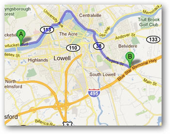
- For Route 3 South, 495 South/West: Continue
east on the boulevard away from the boathouse. You will be on
Route 113 which will take you into downtown Lowell where you
can pick up the Lowell Connector which joins Route 3 and at
a point more south and east than the Drum Hill exit.
This is also your quickest way to 495 in both directions.
For trailers, we recommend avoiding downtown Lowell - get to
495 using the directions in the next bullet.
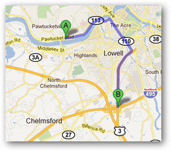
- For 495 North/East, 93 North and South:
Continue east on the boulevard away from the boathouse.
You are on Route 113 which will take you to Route 38, then
495 which intersects 93.
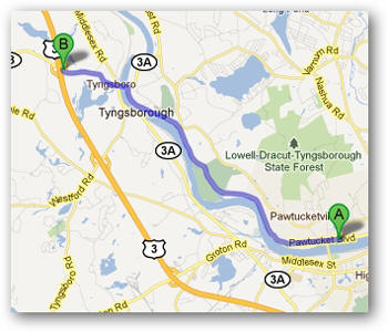
- For Route 3 North: Head west on the boulevard,
but stay in the right lane and continue on the boulevard
- pass the left turn for the Rourke Bridge (which is crowded
with all the folks that haven't read this memo) and continue
heading northwest. A few miles up the road you
can take the Tyngsboro bridge west to get on Route 3 at a
point further north than the Drum Hill exit.
You should figure that the height of Rourke congestion will
be somewhere between 3:30pm and 5pm. So please
consider these alternate routes to make a clean getaway.
If you're facing west from the parking lot when you try
to leave heading east, you can make a right turn on many of
the intersecting streets to get yourself going east.
We will be working with the Lowell PD to make your exit
as pleasant and expeditious as possible.